By William H. Frohlich, Trustee, Huntington Historical Society
The Town of Huntington, as we know it today, extends from the Nassau County line to the Smithtown line in Commack. And, from the Long Island Sound on the north to the Babylon Town Line in the south. But, it wasn’t always that way.
The “original” Huntington Town existed from the Sound all the way to the Atlantic Ocean. Babylon is a relatively “new” creation, which was carved out of Huntington. In 1842, the Long Island Railroad’s Main Line crossed the Town of Huntington through what is now Farmingdale, Wyandanch and Deer Park. Thirty years later, in 1872, a decision was made to split the town into two. All the land lying one mile north of the LIRR tracks remained the Town of Huntington, and everything lying south of that line became the Town of Babylon.
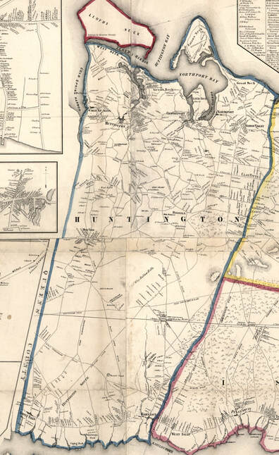
The Long Island Atlas published by Beers, et al, in 1873 shows the new town boundary line clearly, even though the survey work had been done in 1871 and 1872 before the new town had been established. When the atlas was published in 1873, it was correct!
Interestingly, Nassau County didn’t exist either at the time and is also a relatively “new” invention. (Early on there was an attempt made to call Long Island the “Island of Nassau,” but it didn’t stick.) Before Nassau County was established in 1899 it was all part of Queens County, which extended from the East River all the way to Huntington. (New York City, as we know it with its five boroughs, which included Queens County, wasn’t established until 1898.)
What many may not know is that Lloyd Neck remained part of Queens County until the early 1880s. Then, it finally joined Huntington and Suffolk County.
The original settlers that occupied the Town of Huntington bought the land from the local Indian tribes through several purchases in the mid-1600s. Our Town was criss-crossed by many Indian trails which the settlers then used as well. Many of these still exist, but today we know them as Main Street, 25A, Jericho Turnpike, Montauk Highway, among others.
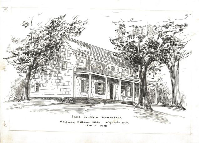
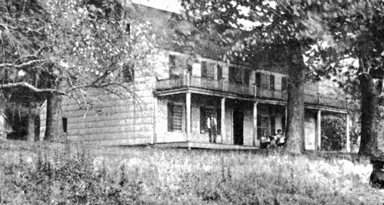
The area that we now call Babylon was unpopulated at the time (sometimes known as Huntington South). That part of Huntington was used mostly as grazing land and for ocean fishing. The first resident was Jacob Conklin, born in Huntington in 1675. He built a house in the Half Way Hollow Hills in 1710 on, it is said, 3,500 acres of land. This original name for the area was chosen for its location: half way between the sound and the sea.
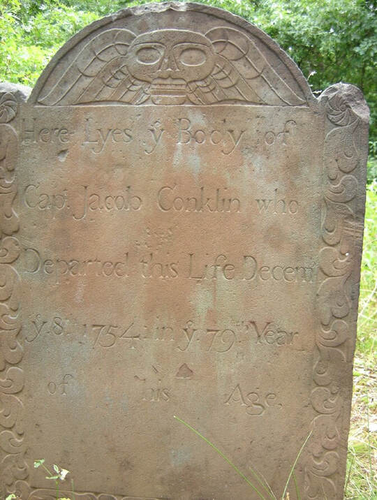
Legend has it that he was an impressed seaman on Captain Kidd’s ship. When the Captain put in to Cold Spring Harbor, Jacob jumped ship and ran south. According to “The Human Story of Long Island,” by Verne Dyson, 1969, “One of the numerous Conklin legends, (is that) his mission was to bury treasure for Kidd; instead he escaped with the chest and from the proceeds bought the estate (land) in the Half Way Hollow Hills.” Some say he hid out in the hollow of a tree for years afraid Captain Kidd would find him!
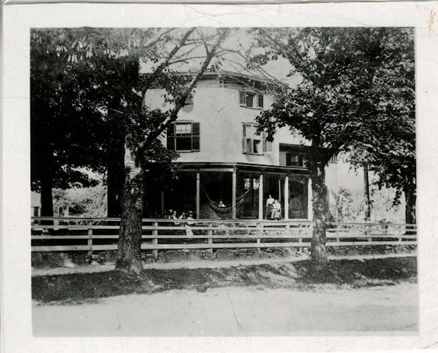
Eventually, he built a house in what is now the Wheatley Heights area on the line between Huntington and Babylon off Bagatelle Road, and married Hanna Platt of Huntington. Unfortunately, the house burned down in 1918. The cemetery where he and his family are buried is still on the property of the the Henry Kaufman Camp Grounds.
The history of the Town of Huntington is a fascinating microcosm of American in its early days. If you are interested in reading more about our local history, find the “Huntington-Babylon Town History,” published by the Huntington Historical Society in 1937. You can also look for the Vern Dyson book and the old maps of Huntington.
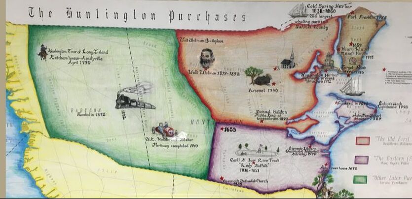
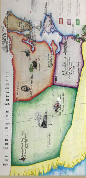
Here the map is shown with its proper North to South orientation.
It illustrates the different purchases of the original Town of Huntington by color.
The red section is the original purchase in 1653.
The purple section indicates the second purchase in 1656.
The brown section denotes the addition of Lloyd Neck in the early 1880s.
The light green area is the Huntington South area.
The railroad (shown in the green area) and the 1872 Huntington/Babylon Town line north of the railroad are also shown.
Thanks for reading!